-
Title
-
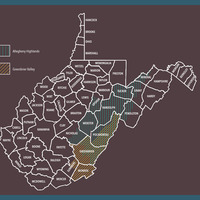
Map of the Allegheny Highlands and Greenbrier River Valley of West Virginia
-
Creator/Maker: For Photographs, Archival Documents, & Artifacts
-
Halley Kurtz, graphic designer
-
Location
-
Watts Museum, West Virginia University
-
Caption
-
Two overlapping, regional designations play essential roles in this history of West Virginia’s timber industry.
Home to a magnificent variety of hardwoods and softwoods, the Allegheny Highlands include the highest peaks in the Allegheny Mountains. Today, much of this area is part of the Monongahela National Forest.
The counties of the Allegheny Highlands are fed by multiple river systems, one of which forms the Greenbrier River Valley. The river systems, and later railroads, connected the Greenbrier Valley with the Allegheny Highlands, forming a transportation and trade network that also linked the region to neighboring counties, such as Braxton and Clay.